Monday, July 30, 2018

Break

This was the original program:

10 FOR X=1 to 3
20 DO HURRICANE RIDGE
30 NEXT X
40 END

For my non-nerd friends, that just means that RandoGirl and I drove to the north end of the Olympic Peninsula this weekend to do the 19-mile climb from Port Angeles, WA, to the top of Hurricane Ridge. The route has over 5,000 feet of elevation gain, and is one of the "must do" climbs in the United States.

RandoGirl would do it once. I planned to do it three times. Why? Because we're going to France for a bike tour in September, and at the end of that tour I plan to try to climb Mount Ventoux on each of the paved roads there. That route looks like this:


So to test my fitness, I wanted to do this:


It's a few more miles and a little more climbing, but I figured that if I could do this route in 12 hours then I should be able to do the Ventoux routes in 12 hours, which is about how much daylight I will have in mid-September.

And so, Friday after work, RandoGirl and I drove to Sequim via a very circuitous route complicated by the fact that EVERYONE was trying to get out of Seattle for the weekend (since the forecast was for temperatures near 90) and NEARLY EVERYONE was apparently trying to go to the Olympic Peninsula. Thus, we didn't get to our hotel until after midnight, which meant we were still a little tired the next morning when we got up to drive to Port Angeles and start climbing at 8 am.

But, like I said, I just wanted to see if I could climb this thing three times in 12 hours. Easy.


It was cool in Port Angeles, so RandoGirl kept that jacket on for most of the climb. After the first mile, I pulled off those arm warmers ... right after I realized that I was missing my left glove.


The road for the bottom five miles was under construction, and that's also where the steepest stuff is. But the steep stuff there was rarely in double-digits, and I've been riding a lot of really steep stuff around Seattle lately, so it was rarely hard enough for me to even get into my 28-tooth gear on the back. I paid $15 for a pass at the gate and made sure that it was good for the whole day (it's good for a week), and then took a break about halfway up before entering the first of a series of three short tunnels.


I also turned on my rear light here, since there were a good number of cars. Most of them passed properly, some passed a little close, and quite a few passed with a wave and/or a thumbs-up.

Just before the last tunnel I passed a touring cyclist, and then I passed a couple of other cyclists a mile further. One of those looked to be a guy in his 70s, but he was still churning along. The other fellow was much younger, and he passed me back about another mile further on. Part of me wanted to kick harder to stay with him, but I told myself to take it easy since this was a "for the long haul" kind of day.


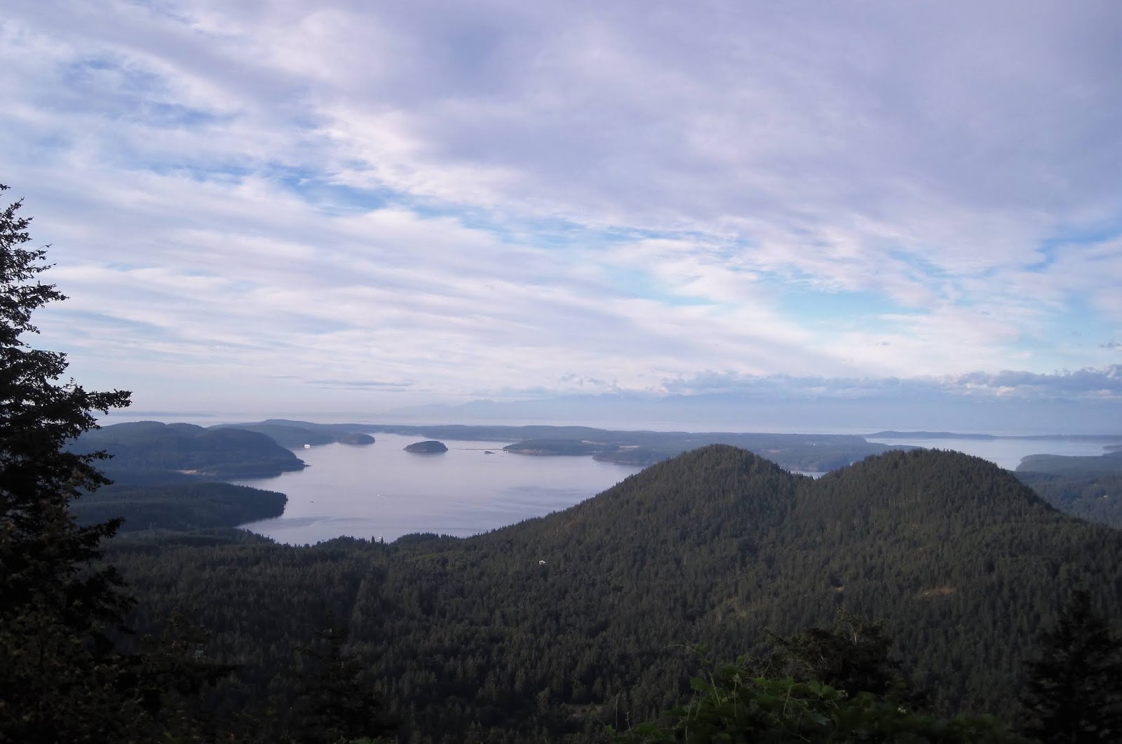
Nearing the top, a couple of fellows on bikes came zipping down, "Woo-hooing" all the way. Pretty soon after that, I first saw the ridge.


About here you begin to see people hiking along the top. Then you come around the corner into a parking lot full of cars.


I felt pretty good at this point. My goal had been to do the climb in three hours, and I'd managed to finish in under 2.5 instead. The worst part had been the incessant biting black flies over the last eight miles. I snapped a quick picture of my bike under the sign and started down.


On my first descent, I rode the brakes so much that my hands began to hurt. Frankly, this is one of the carry-overs from my mishap in Andorra a year ago: I tend to be cautious going down any hill the first time. I saw RandoGirl after five miles or so and yelled "hello," and then loosened up a bit to have fun again ... until the bottom five miles. As I said earlier, that part is steeper and under repair, so controlling my speed and dodging holes kept my busy. After hitting a few holes and skating through a couple of gravel patches, I was glad to be done with the descent.

Back at the car, I topped off my water bottles with ice and Gatorade, ate a couple of bars, and started back up. As I climbed the bottom section again, I started to modify my original program.

10 FOR X=1 to 2
20 DO HURRICANE RIDGE
30 NEXT X
35 DO HALF HURRICANE RIDGE
40 END

My thinking here was that maybe I should just climb this thing twice, and then come back to the gate and not have to descend the steep bumpy section again ... plus not have to climb it again.


About a mile before the gate, more cyclists came down. One of them stopped and asked me something, and I recognized him as the fellow that had passed me on the way up earlier. He repeated his question, "Do you want to use my pass?" I said, "No, I bought one the first time up." Then he looked at me strange and said, "Oh, yeah. I remember you." By then I was past him, but I'm pretty sure that he was thinking, "What kind of masochist does this thing twice?"

At the gate, there were almost 50 cars stacked up waiting to be allowed in. I rode past them to the booth to see if I needed to wait in the line. The Park Ranger asked if I had a pass, so I showed him mine and said, "Yeah, I bought it when I came through the first time." "The first time?" "Yeah, I went by here about 9 am. There weren't as many cars here then." "They're waiting for parking spaces up top to open up." "Okay. Thanks. I'll see you again in a couple of hours."

As I rode on, I'm pretty sure that he was looking at me then about the way that the cyclist had been earlier.


By the time I got back to the parking lot before the tunnel, I was tired.


The fog had lifted from Port Angeles, and it was getting pretty darned toasty on the mountain.


I paused to read the placards this time.


But eventually told myself, "it ain't getting any cooler. And the top ain't coming to me." So, off I went.


The flies were now impossible. The first time, it had been a little cooler and there weren't as many, but now they were swarming. Worse, I didn't have the legs to regularly sprint away from them, and had not thought to bring any bug spray in the car or "Off" wipes in my pockets. So my only recourse was to swat them out of my face and smack any that landed on me ... mostly on my backside, where they could more easily bite me in the butt through my sweat-soaked shorts.

Just before I lost cellular coverage, I got a text message from RandoGirl that she was done and heading to get some lunch. It was just after 2 pm when I summited for the second time.


This time I took a break. I finished off my second bottle, ate my other bar, and walked around the visitor's center for a bit.


As I started down, I thought about whether I wanted to go to the gate and start back, or if I should head for the car.

10 FOR X=1 to 2
20 DO HURRICANE RIDGE
30 NEXT X
35 INPUT "HAVEN'T YOU SUFFERED ENOUGH?"; R$
40 IF X="Y" THEN END
50 DO HALF HURRICANE RIDGE
60 END

To be honest, I'd proved my point. It took me seven hours to do the equivalent of the Malaucene and Bedoin climbs -- the tough ones -- up Ventoux. I could have gone back to Port Angeles, eaten lunch, bought a bottle of Off spray, taken a nap, and climbed back up again in the five hours of daylight that I had left. And, yes, the mistral winds blowing around Ventoux might make me descend even more slowly that I was on Saturday coming down from Hurricane Ridge. But you can't foresee the weather -- you can only train for something to the best of your ability and hope that the plan comes together and your program pays off.

I pressed Y, and was back at the car around 3 pm.

Wednesday, July 18, 2018

The Racer's Edge

I was a kid when I first heard about STP.


But it was probably only a few years ago that I first heard about the other STP: Seattle to Portland. You can do this 205-mile ride as a two-day event, but doing it in a single day sounded interesting in the same way that Cross-Florida sounded interesting when I lived down there. So, for some insane reason, even though I haven't even done a 200K this year, I decided to ride STP this year. Worse, I decided to do it fast enough that I could finish before sunset, so that I wouldn't need to bring lights.

My plan was to keep this low-impact. I didn't want to have to drive a car up to the start at 4:45 am, and I certainly didn't want to make RandoGirl get out of bed to drive me up there then. After the ride, I wanted a simple way to get back home.

So Friday evening I carried a backpack with a change of clothes and toiletries over to the University of Washington campus and put it on the truck for Portland. Then Saturday morning my alarm went off at 4:30 and I left the house on my bike just after 5 am.


The streets were mostly empty, of course, as I passed over the Duwamish and through Georgetown. Just east of I-5, my Wahoo GPS popped up with a warning that the battery on my electronic shifting was low. I had just plugged my beloved Bianchi in two days earlier to top off the battery, and decided that this must be an error ... some kind of mis-calibration.

(Cue ominous foreboding music.)

I hit the route just south of where the "real" route left the Lake Washington Loop, my shortcut from home shaving almost half a mile from the full course. Although my legs were thus much more fresh than those of my fellow riders, many of them continued to pass me as we headed into the sea of traffic lights known as Renton.


There was a broad array of skillsets and fitness on display here. Large groups would zoom past just to get caught at the next traffic light. Wide bunches would weave about the lane chatting about their grandkids or listening to bluetooth speakers bolted to their handlebars or just churning and chuffing and offering up their suffering like supplicants in hair shirts.


(If you look closely, you can see Mount Rainier in this picture.)

It would have been nice to sit in on a good group here. It would have been nice to sit in on a good group at any point during the day. However, such respite remained unavailable to me. Maybe I'm too picky, or maybe I missed the "good" groups, but any time a bunch of riders came by that appealed to me I would join them for a mile or two and then we would suck up some squirrelly miscreant that would start surging or couldn't hold a line or would run a stop sign to the obvious ire of the screeching tires and blaring horn of a loudly cursing nun.

So I rode alone awash in a cycling sea of humanity, feeling like an aborigine on a crowded New York subway train. Occasionally I would chat with another rider, but most of our interchanges were along the "On your left" and "Good morning" variety. More often, a string of riders would form behind me, like remoras trailing a grizzled Great White, happily bobbing in my wake as I lumbered stupidly on.

Although STP is a supported ride, I had skipped all of the stops through Puyallup. At the top of the climb past there, however, I made a brief stop for coffee.


Caffeine is the REAL racer's edge.

Just past Spanaway, the route turned onto the grounds of Joint Base Lewis-McChord. Signs there warned against taking photographs, with penalties of fines and imprisonment. I looked around and noticed bunches of GoPros on riders helmets, capturing every moment of the ride's epic-ness (epicocity?). But since I'm a rule-player, this picture is NOT from on the base. Honest.


Speaking of rules, the Cascade Bicycle Club was also very clear on riders' use of headphones on the ride. I'm sure that all of the earbuds that I saw jammed into peoples' heads were really hearing aids. Made by Apple.

I had just left the base and was almost a third of the way into the ride when my electronic shifting completely quit. Ordinarily, with Shimano Di2, when the battery is dying it first stops shifting in front; however, I had been big-ringing everything for the past 20 miles, so it had no recourse but to just leave me in the middle on the back and big ring up front. I pulled over to make sure that it wasn't a loose connection, but the little red lights do not lie: My battery was bereft.

Now, I had just been thinking earlier in my mindless musings that this would be a good route to ride on a single-speed bike. The wind was predominantly out of the north pushing me along, and the hills were mostly of the long lumps and/or gentle roller variety. In 2008, I rode my Salsa Casseroll on a fleche that went over the mountains between Tennessee and Alabama, so if I could ride 240 miles through that then surely I could do the next 135 now.

But I was young in 2008, and had all kinds of fitness left over from riding the Rocky Mountain 1200K earlier that month. Could I do the next 135 miles using only the gear to which my lack of juice had sentenced me? Yes. Could I finish by dark? Possibly.

But I want to.

Amazingly, one mile down the road was a rest step. Even better, it had a bike support tent that had been set up by the Montlake Bicycle Shop. I asked the mechanic there -- Gary TeGantvoort -- if he had a Di2 charger. He said no, but that he did have a Di2 battery that he had thrown in the box at the last minute.


So Gary proceeded to finagle the battery out of the seat post on my Bianchi.


And put his almost-fresh one in. Voila! I was back in business.

After profusely thanking Gary and promising to return his battery on Monday, I topped off my bottles and headed back out. In Yelm, we got on a multi-use trail for a few miles.


While it's nice to have these trails, I wish that they would pave them using at least some of the same standards that they use for roads. The lumps from trees pushing up the pavement are always in the shade, and they get tiresome.

In Bucoda the multi-use trail ended, and a few miles later we were at the mid-point of the ride at Centralia College. There were banners and a few folks cheering, and many riders gladly hit the beer garden set up there. It was not yet 11:30, however, and I still had over 100 miles to go. So I headed straight for the food trucks in the back.


I got a pretty good sandwich and an order of fried pickles, seeking to stave off the kind of cramps common for a ride of this effort and length -- not to mention the heat quickly ascending upon us. Chatting with some fellow riders and their families at one of the picnic tables, I learned that some folks had started a little earlier than the posted 5 am time.

This did not surprise me, since I had been passing people all day that did not seem like the types who had gone out too hard too fast earlier and were now spent. Sure, there were lots of those, but there were also a lot of people whom I would not have picked as cyclists if I met them on a bus or on the street ... or at a hot-dog eating contest. I certainly wouldn't have pegged them as cyclists capable of riding a century, much less riding 205 miles.

But I continued to see these people, even after leaving Centralia. They were obviously suffering , particularly on the hills or in long sun-filled stretches. Many of them had loved ones in cars and vans that would pull over on the side of the road and wait for them to come by for support. And maybe some crawled into those cars and vans and decided that today was not their day. But to the ones that I saw who were still out there trying, and to the ones who made it all the way: Congratulations. Your achievements dwarf those of the other cyclists who ride STP.

As, frankly, does your belly.

(Classic RandoBoy Snark. Patent pending.)

Leaving Centralia, we wandered briefly into farmland before passing through Chehalis.


I had picked up a few remoras who thought that I knew the route. We got passed at an intersection by a couple of fellows that I could only assume were Mormon missionaries -- white shirts, ties, black pants, and no helmets. They took a left, and for some reason I followed them for about 50 yards until my GPS started flashing red.

"Beware false prophets," I said to myself, making a quick U-turn.

The next few miles had us weaving through lovely fields along the interstate before heading off to Napavine and Evaline. A young lady got on my wheel here, and was one of the few who said something to make her presence known. When I stopped in Winslow to refill my bottles, I realized that she was wearing a long-sleeve cotton shirt and cut-off blue jeans, and that she was riding what looked like a heavy steel commuter bike -- complete with fenders.


Again, however, she had been good on my wheel and was riding strong, and I have little doubt that she was able to make it all the way to Portland that day. "You can't judge a book by its cover," I thought, considering that maybe I shouldn't be so picky about who I'm willing to sit in on. But then, there's a big difference between paying too much for a crappy paperback at the airport and being the third guy in the pileup caused by a conflagration of Freds.


And so I rode on, alone in an ocean of Orbeas. I confronted Vader, and began to sense an eruption in the saddle area as I came even with Mount St. Helens at Castle Rock. When I got low on fluid, I typically bypassed the official rest areas and opted instead for the nearby convenience store. They had ice and a better array of drink choices, and I could grab a Payday candy bar to eat on the road.

Near mile 150, we entered Kelso and Longview. Climbing the Lewis and Clark Bridge, you get your first view of the Columbia River ... and the millions of logs awaiting transformation into trusses.


As you would expect -- it being the only bridge over the river between Astoria and Portland -- the road was busy, and I was ecstatic to reach the other side.


It was now officially hot, and there was not much shade on Hwy 30 in the middle of the afternoon, so I just put my head down and motored as best I could. There were a few official SAG spots along this stretch, and I hit one to fill bottles and use the facilities. I wondered if I looked as tired and beat as the other riders there, sprawled and sweating under the tent.

My bottles were nearly empty as I hit the outskirts of Portland. With over three hours of daylight left, I should have stopped at one of the McDonald's or other fast-food options for a break and to fill my gut, but I kept thinking that if I did that then I might get a flat or some other delay that might imperil my no-night-riding goal. And thus I soldiered on.


I was ecstatic to cross this bridge into the city proper with a group of riders, although at this point I was also beginning to feel queasy. "Should've stopped at McDonald's," I told myself again.


The day had taken its toll by now, and the last seven miles to the finish line were a brobdingnagian effort. After rolling under the banner and waving back at the cheering crowds, I collapsed onto a park bench, half in the sun. A lady selling bicycle jewelry (not jewelry for your bike, since that would be crazy, but jewelry that was cycling-themed -- you know?) gave me three much-needed mini-Tootsie rolls. After a couple of minutes, I was able to stumble over to a food vendor and get a strawberry lemonade and a Diet Coke. Then, I just sat.

Batteries now less drained, I retrieved my backpack from the drop and checked into my hotel a mile away. Pouring myself a bath, I couldn't unzip by jersey because of all of the salt.


Suddenly, the way people had been looking at me for the past few hours made sense.

I walked to a pizza place for dinner, and then picked up a few bottles of water to drink during the night and an ice pack for my left knee. I spent a fitful night fraught with twitching legs and sore joints before checking out of my hotel and going for a doughnut.


It was early enough on a Sunday morning that the beleaguered night people were still about, slowly dissipating as the next shift clocked in driving SUVs on their way to a non-denominational service. I bought one old fellow a doughnut because he asked me to, and a cup of coffee because he needed it. Then I headed for the train station and caught the 8:20 back to Seattle.


I won't do this ride again, at least not in one day. I'm glad that I did it once, if for no other reason than because it is supposedly a core Seattle cyclist experience. But it was the kind of experience for which I am frankly getting to be too old. I obviously still have the ability, but the interest is gone.

Monday, July 16, 2018

Tour de Vancouver: Bringing it all Home

What are you doing here? The trip is almost over and you've cut in line! You won't understand a thing here unless you've read this blog, and then this blog, and then this one, and then this one. Go read those first. Do your homework! Clean your room! And stay off of my lawn!!!

July 7: Seattle Again

When I first planned this trip, the last day was going to use the route that I had taken four years earlier to return to Seattle. But between that and July 7, RandoGirl and I bought (more or less) a house on Bainbridge Island. I wanted to show everyone the house and a bit of Bainbridge -- plus, I knew that the Silverdale and Bremerton sections would be busy and unpleasant -- so I altered the route.

After another huge breakfast, we left Port Townsend by following the old route and getting on the Larry Scott Trail to go by the paper factory. Parts of this were paved and other parts weren't, and we got confused a few times, but eventually it ended about the way that I remembered and we had to get on Hwy 20 for a mile. Fortunately, that road has a decent shoulder and the Saturday post-holiday traffic was not too bad, and soon we turned off on Hwy 19 towards Irondale.

In Port Hadlock, we got on Oak Bay Road for a fast run towards Port Ludlow. The shoulder here was not as good and traffic was both heavier and more aggressive than I remember from 2014. I was happy when we finally turned on to Paradise Bay Road after a brief stop at a convenience store for coffee and rest rooms.

Traffic was definitely heavier crossing the Hood Canal Floating Bridge, but we had the big shoulder so that was no problem. On the other side of the bridge, Steve and Joyce passed us in the van. They turned right, as was our original plan. But we turned left to follow the new route.

In retrospect, I wish that we had turned right since most routes seem to favor taking Hwy 3 to Big Valley Road, and then coming up from Poulsbo. I had opted for fewer miles and hills, so we turned left on Hwy 104 through Port Gamble, east on Hwy 307 towards Kingston, and then down Miller Bay Road. All of those were busy with a shoulder that came and went and often had debris, and were not very scenic either. We were so happy to get to the end of that, past the casino, and over the bridge onto Bainbridge Island that nobody wanted to stop for a picture of Agate Passage.

Once on the island, we turned off onto some of the quieter roads along the west coast. Everyone was pretty tired by now, so we cut off some of the southern sections and headed into some nice Bainbridge Island neighborhoods.


Then we went down to the Harbour Public House where we had a huge late lunch. We caught the ferry afterwards and most of the team took the water taxi to Alki Beach and back to the house. Jeff Bauer and I didn't want to wait for the ferry, so we bombed down the roads instead -- not realizing that Cathie was also going with us. She got a little lost, but made it home fine a little later.

Back at our house, we all hung out drinking and chatting and packing up bicycles. The next morning, Jeff, Tom, and Judy flew back home while Steve, Joyce, Jill, and Cathie did sight-seeing. Then we loaded them up and they flew back.

In spite of a few challenges, it was a good trip. It must have been, since everyone is already asking when the next one is and where we will be going. Hopefully by then I will have ridden a few more of the roads so I better know what to avoid.

Friday, July 13, 2018

Tour de Vancouver: Island Time

Today's blog is about a long trip, so it's broken into multiple entries. For stuff to make sense, read this one, and then this one, and then this one. Then come back here.

July 5: Orcas Island

Today was one of the best routes, but it was also one of the toughest. And that's how things should be.

Tom and Judy were good to ride with us again by now, so Jeff took over in the van. He did an excellent job staying close and being available in case the route was too much for the battered couple, but Tom had recovered very well and finished strong. This also gave Jeff a chance to find a replacement for his rear derailleur cable, which had crapped out for the last 15 miles of the previous day's route. To someone who is so used to riding fixed gear bikes for 1200Ks or RAAM, however, it was nothing to Jeff.

After a huge breakfast at the hotel, we passed through an apparently sleepy and/or hung-over Bellingham and returned to Chuckanutt Drive.


It's good to have a camera with a timer. Let's you run around and get in the shot ... even if it took four tries.

Since Tom and Judy didn't get to bike through here last time, we took it easy. Then we put the hammer down when we got back to the flats.


We were making very good time, and our lunch stop at Edison was almost "second breakfast." Jeff joined us, having finally found a shop with a Campagnola derailleur cable (who'd have thought that Campy would even have to go weird on their cables?!).


Back on the road, we passed a lot of cyclists heading north.


Some just looked like day riders, but there were quite a few touring cyclists as well.


Eventually, the quiet road along the water smacked into busy Highway 20. But this road had a good shoulder and we were only on it for long enough to get over the channel and on to Fidalgo Island.


We then turned onto a road through a more industrial section of town -- nice and quiet -- before heading out past the refinery and onto this lovely bridge.


Yeah, we all took pictures of it. It lead to a multi-use trail ...


... that included totem poles near RV parks ...


... and views of Anacortes industries across the water, with Mount Baker in the background ...


... before finally entering Anacortes via a field of dry-docked pleasure boats.


We cut through a couple of quiet neighborhoods before getting back on Highway 20 for a couple of miles. The shoulder here came and went, and the cars did not seem happy to be sharing the road with us. Just before the ferry, there was a sign saying "Bike Lane Ends." I laughed, because there were no markings for a bike lane. Some "Share The Road" signs would have been better, or preferably a couple of "Bikes May Use Full Lane" signs.

Either way, we had over an hour to the next ferry. I even changed out of my bike clothes as we hung around waiting to see if Jeff could get on with the van. He did, and we soon boarded the boat.


Some of us napped and read, while RandoGirl and I worked on one of the dozens of jigsaw puzzles that were on the tables. Soon, we were on Orcas Island.


Steve and Joyce's wheel had gone flat during the ride, but since the van was there it was easy to change and soon we were crossing the hills on this little island. We buzzed through Eastsound and headed south on the other side, where we had a long climb followed by a steep descent down to Rosario Resort.


The resort was busy due to the holiday. It was after 8 pm by the time we got checked into our room, put away our stuff, and got cleaned up, so we opted for the simple dinner at the grill down by the marina.

July 6: Port Townsend

Since we were all sharing driving duties, today was my day in the van. I chose it because I knew that the two ferry crossings would be tricky, and because the route today was fairly straight-forward.

However, I still needed a ride. And, since today was the one-year anniversary of my crash in Andorra, I had something to prove. So I climbed Mount Constitution -- the highest point on the San Juan Islands.

It was not yet 6 am when I headed out of the resort and did the very tough climb back to the main road. I then turned right and within less than a mile entered Moran State Park.


All of the campers were still asleep as I passed through the campground and the lake.


The deer, of course, were up.


If you ever go to Orcas Island, you will encounter a bunch of deer that have almost no fear of humans. I even saw a couple of young bucks, who barely looked by as I rode past on my bike.

I soon turned off on the dead-end road that climbed the mountain.


The bird on the sign had probably already enjoyed his worm.


The park was a CCC project back in the 1930s, and some of the bridgework and railings are still in use. Just past this bridge I got to a closed gate a little ways beyond the last of the RV parking. A sign there said that the gate opened at 7 am. Since it was almost 7 am, I hoped that they wouldn't mind me jumping the gate early.


A park ranger passed me a little later near here, but did not say anything to me about jumping the gate. Most of the Orcas Island people that I met were very chill, so he probably figured "no harm, no foul." A refreshing point of view from a government worker nowadays.

Halfway up, I stopped at a scenic overlook.


A guy in a truck pulled up next to me and began to unload his bike. We chatted briefly, and he told me he was just climbing up from here. He agreed that the toughest part of my route was getting out of Rosario.


He was right, too. The rest of the way up had a few short 10% and 11% sections, but it was all easier than riding around Vashon Island. Soon I was at the top.


Pictures fail to capture the view from up here, since you can see virtually all of the San Juan Islands.


It was windy and cold, and I knew that RandoGirl would be worried about me, so I started down.


Although the climb had been hard physically, the descent was rough mentally. I rode my brakes almost all the way, through every curve and switchback and moderating my speed on the few straight sections, thinking about how far I had come in the year since my crash ... and trying to block out thoughts of ever having to do that recovery again.

Obviously, I made it down. The steep stuff into Rosario was worse in some ways, but better in that I knew it now, and soon I was back at the hotel.

The group had opted out of the steep climb back to the main road, instead ferrying people and their bikes via the van. I took the last folks up, took their picture, and then headed back to the room to pack everything up.

Once our bikes and all of the bags were in the car, we drove to Eastsound and had breakfast with everyone. Then we headed to the ferry in hopes of getting on an earlier boat. Fortunately, island life was in full swing, and the guy at the gate gave us the green light. The car and all of the cyclists thus made it to Anacortes together.


We took Marine Drive out of town -- a lovely road, but very lumpy -- and then followed Rosario Road back to Highway 20 at Deception Pass.


We checked in with the riders via text and they were doing well. So we went on past Whidbey Naval Air Station ...


... and stopped in Oak Harbor for lunch.


The riders took a less busy route on the west side of Whidbey Island. While it meant fewer cars and nicer views, it also meant that they were having a hard time finding food options. Nonetheless, they were still doing well, so RandoGirl and I headed down to Coupeville to see if we could catch an earlier sailing of the ferry to Port Townsend. It meant sitting in the van for about an hour and a half, but they were able to squeeze us in after a couple of boats came and went.

Since we were at least one boat ahead of the group, we had time to check in and lug our bags up to our third-floor room. We were staying at the Palace Hotel -- a lovely old place that was once a notorious brothel and is now supposedly haunted. Since it's old, it did not have an elevator. And since it's the Pacific Northwest, it did not have air conditioning. We opted for a walk to see the town while the stuffy room cooled.


We got back to the room about the time that everyone came in. We helped with bags and bikes as much as possible. After everyone got cleaned up and dressed, we went out to another great dinner at the Silverwater Cafe. When we got back to our rooms, they had almost cooled off enough that we could enjoy a restful night.